


We’ve used Ride with GPS to build, share, and navigate routes for more than a decade, and to help our readers get the most out of their rides, we’re sharing a year-end recap of the platform’s latest features and tools. See what’s new in 2025 here…
We’re closing out the year with a quick recap of the latest features and tools Ride with GPS has released and updated, helping our readers get the most out of their rides and routes, regardless of if that’s something from our worldwide network or an original creation. Whether you’re a seasoned Ride with GPS user or just getting started, familiarity with the features outlined below will help you maximize your time planning, riding, and sharing your backcountry adventures—from early research to real-time navigation to post-ride storytelling.
Ride with GPS is currently offering 15 months of Premium membership for the price of 12 months, and 10% of that purchase price will be donated directly back to us to help us grow and maintain our global archive of 125,000 miles of routes. If you’ve been considering a Premium membership for yourself or want to give one as a gift, you can access the limited-time offer here. Without further ado, let’s dive into our 2025 Ride with GPS recap.
Waypoints
Waypoints add structured, customizable markers along a route—camp spots, water sources, resupply locations, viewpoints, hazards, trail junctions, and more. Each waypoint integrates with the elevation profile and cuesheet, ensuring riders aren’t simply “following a line” but instead navigating with context.


Key points:
- Compatible with most Garmin units and both Gen2 and Gen 3 Wahoo devices.
- Audio notifications for waypoints when navigating with the Ride with GPS mobile app, as well as Garmin and Wahoo devices.
- Critical trip information appears in cues and on the map at the exact moment needed.
- Estimated Time between waypoints using the mobile app, which updates in real-time based on your current riding speed.
- Supports safer decision-making through visibility of hazards or key decision points.
- Allows for easy mid-ride updates if riders discover better campsites or conditions.
Collaborative Route Planning
Ride with GPS enables multiple riders to work together on a single route. Planners can edit a route, leave comments about the changes, view updates instantly, and roll back to previous versions when needed. This removes the friction of passing GPX files around, consolidates key decisions into one shared workspace, and ensures each group member can contribute knowledge about terrain, closures, traffic, or local conditions. Collaboration makes it easy for planning responsibilities to be shared rather than falling to a single person.


Key points:
- Collective editing replaces messy file-sharing and version confusion.
- Integrated comments allow editors to easily share updates with collaborators.
- Version history allows instant recovery from mistaken edits or conflicting ideas.
- Ensures all riders communicate and plan from the same source of truth.
Collaborative Collections
In addition to route collaboration, Ride with GPS now supports co-owned Collections—shared folders that organize all assets for a bikepacking trip. Riders can gather final routes, alternate tracks, resupply points, informational links, scouting photos, and previous ride data in a single, accessible hub. Collections act as a central “home base” for trip planning and later as an archival record for sharing or repeating the route.


Key points:
- One place to organize and access all trip materials.
- Reduces pre-trip logistics by eliminating scattered files or conversations.
- Makes group trips more self-sufficient and reduces reliance on one coordinator.
- Ensures future riders have complete context for repeating or modifying the route.
Community-Generated Highlights
Community Highlights surface scenic viewpoints, water sources, camp locations, technical challenges, and other points of interest added by other riders. Bikepackers gain access to local knowledge from people who have already ridden the terrain, making the route feel richer and more informed.


Key points:
- Rider-generated intel transforms maps from static lines into lived experiences.
- Helps uncover hidden gems or practical necessities that don’t appear on traditional maps.
- Encourages discovery without requiring deep local research.
- Builds a community-driven cycle of shared knowledge for future adventurers.
- Easily convert Highlights into Waypoints for integration across mobile and your preferred GPS device.
MTB Trail Layer
The MTB Trail layer adds highly detailed trail classifications to the map, including ratings like Green, Blue, Black Diamond, and Double Black. For bikepackers navigating mixed-terrain routes, this gives essential insight into what is rideable, what is technical, and what might require alternative lines depending on riders’ skill levels or bike setups.

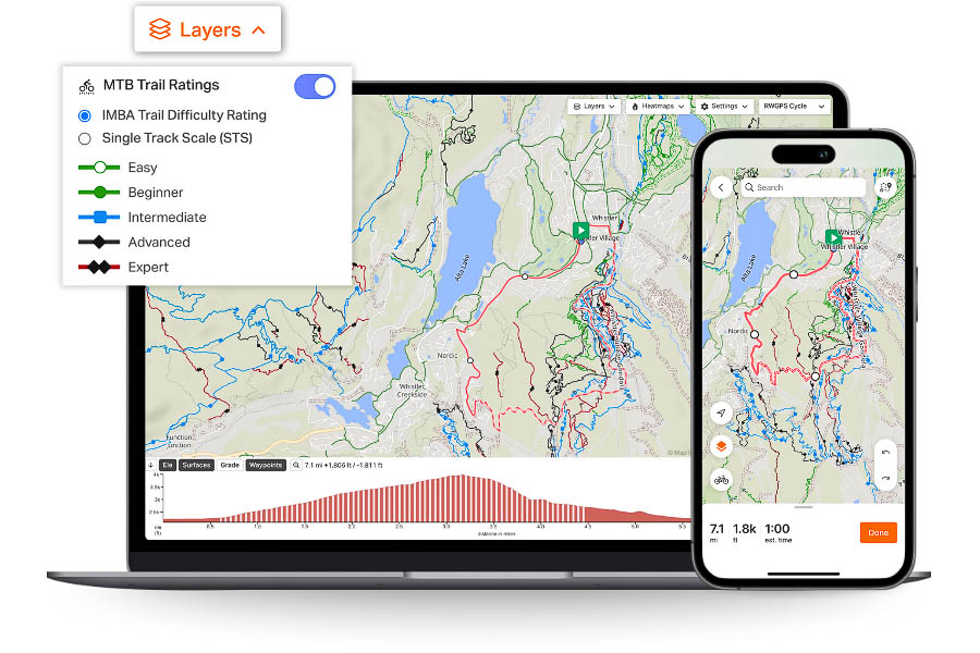
Key points:
- Clear visibility into trail difficulty before committing to a segment.
- Safer decision-making, especially with loaded bikes or limited mobility.
- Enables skill- and gear-appropriate route design without guesswork.
- Reduces surprises and helps avoid terrain mismatches in remote areas.
Collectively, these tools create a more predictable, transparent, and enjoyable experience before, during, and after a bikepacking trip. Pre-trip, riders collaboratively develop a route, evaluate difficulty, and prepare key logistics. On-ride, waypoints and trail difficulty support safe and confident navigation. Post-ride, shared collections and community highlights help riders document and share their journey for others to follow.
What features and tools would you like to see in 2026? What questions do you have? Let us know in the Conversation below!
FILED IN (CATEGORIES & TAGS)
Dispatch
Please keep the conversation civil, constructive, and inclusive, or your comment will be removed.


