


Felt is a new easy-to-use mapping tool that shows great potential for sketching out bikepacking routes and planning trips with others. Find a number of bikepacking use cases we’ve found and some example maps below…
Released to the public back in June, Felt is a powerful yet easy-to-use digital mapping tool that could shake up the powers that be in the mapping and route-planning space. One of its key features is the one-click sharing, inspired by the likes of Google Docs and Figma, which makes it easy to mark up the map with others. It’s free to use, and I’ve been having a lot of fun exploring its functionality for bikepacking.
Felt is basically a digital whiteboard with an interactive map as the backdrop, so it serves a different purpose than familiar route planners such as Ride with GPS. The latter are specialized GPX file editors, whereas a Felt map has a much broader scope, containing hand-drawn lines and shapes, text notes, emojis, images, links, points of interest, routes, and more. Felt also doesn’t replace a dedicated topo map service like Gaia GPS or OSMand, which provide a much richer and more detailed base map and layers for land navigation.
I’ve found it an intuitive tool for representing bikepacking routes with all the additional info that’s not the GPX trace. I recreated my Lost-in-Brandenburg Loop in Felt below. Note the highlighted sections with fallen trees and alternative tracks parallel to the main route. It’s really easy to mark alternative segments, off-track points of interest, and keep the map up to date with rider feedback.
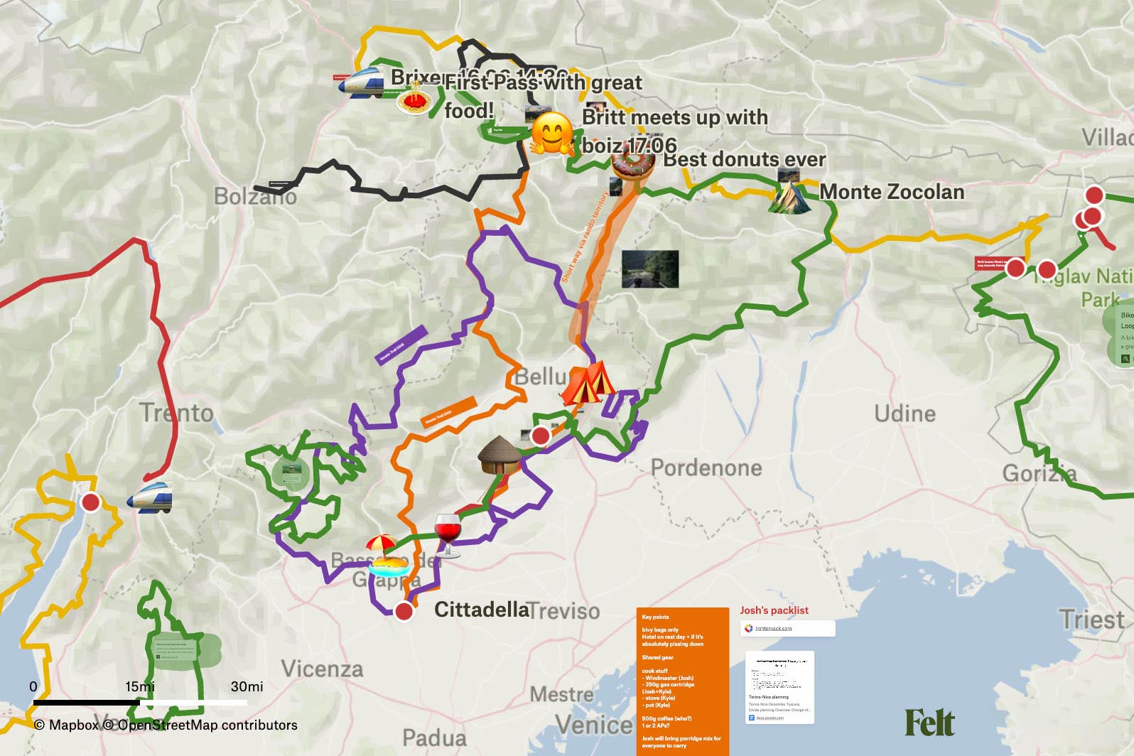
We tested Felt as a planning tool for a group trip down to the Dolomites and found its easy sharing and collaboration features allowed everyone to chime in with their suggestions and ideas, be that routes, points of interest, or sketches on the map. I can also see a Felt map acting as kind of a master document for complex route projects involving multiple people. With the rich marking and styling options available, it’s possible to identify likely corridors, aggregate GPX files from scouting missions, mark segments that need work, and keep track of alternates.
Since Felt is a general-purpose tool, it’s still missing many crucial features for navigating off the grid. First and foremost, an app that functions offline is sorely needed. The base map style is quite sparse and low on contrast—ideal for layering datasets on top but less suited for getting a read of the terrain. A richer map style, perhaps implemented as a toggleable layer, would be valuable for navigation purposes. A rudimentary GPX file editing module would also be handy for truncating imported files, and some way to display a route’s elevation.
The team at Felt has been introducing big features on a weekly basis, and in my correspondence with them, they’ve been responsive to my issues and feedback. They seem keen to learn about the unique needs of niches like bikepacking, so it’ll be interesting to follow along and see what they have in store for navigating outdoor adventurers.
Head over to Felt.com to make some maps, and let us know in the comments where you see its value for bikepacking.
FILED IN (CATEGORIES & TAGS)
Dispatch
Please keep the conversation civil, constructive, and inclusive, or your comment will be removed.


