


Central Wasatch Traverse
Distance
153 Mi.
(246 KM)Days
4
% Unpaved
75%
% Singletrack
50%
% Rideable (time)
95%
Total Ascent
22,778'
(6,943 M)High Point
9,896'
(3,016 M)Difficulty (1-10)
7?
- 9Climbing Scale Very Strenuous149 FT/MI (28 M/KM)
- 8Technical Difficulty Difficult
- 8Physical Demand Difficult
- 4Resupply & Logistics Fair
Contributed By

Taylor Hunter
Guest Contributor
Taylor grew up in Southern Michigan, where BMX fueled his childhood. After moving to Salt Lake for the snow, he stayed for the dirt. He’s explored a good part of the world by bike but now favors rides close to home in Utah and Idaho. See more of his adventures on Instagram @taylor_hunterr.
Rising from the valley floor in steep, rugged folds, Utah’s Wasatch Mountains hold a network of historic trails, high alpine ridgelines, and world-class singletrack. The Central Wasatch Traverse stitches them together in a 140-mile ride from Farmington to American Fork. Starting in Farmington, the route wastes no time climbing into golden desert foothills before diving into a mosaic of alpine ridges, aspen groves, and pine forests, linking 19th-century pioneer trails with modern singletrack classics. Along the way, riders experience a rare combination: raw and remote terrain balanced with easy logistics, frequent resupply points, and public transit at both ends. Woven with Indigenous and pioneer history, après-ride havens, stunning backcountry scenery, and convenient access to welcoming mountain towns, the Traverse offers an unforgettable bikepacking journey through the beating heart of Utah’s most iconic range.
The route threads together some of the most storied paths in the West. The Great Western Trail, envisioned in the 1970s to connect Canada to Mexico, overlaps with centuries-old corridors like the Mormon Trail, used by pioneers long before mountain bikes existed. These historic routes flow into modern singletrack icons like the Wasatch Crest—one of the most celebrated alpine rides in the world—and the aptly named Wasatch Over Wasatch Trail (WOW), a winding descent through forest and flower-filled meadows. South of Midway, a town with deep Swiss heritage, the Traverse climbs again toward Mount Timpanogos, following the Ridge Trail along sheer alpine slopes before dropping into American Fork via the Grove Creek Trail, a dramatic descent through towering rock cliffs where the path feels almost impossibly placed. A bit of hike-a-bike may be needed in spots, but the effort is worth it, with a natural spring at the top feeding waterfalls that cascade down the rugged canyon walls.
The terrain is as varied as the history. Broad dirt roads like Jeremy Ranch and the Skyline Trail allow moments of cruising and recovery, while technical singletrack sections demand focus and reward with stunning views. High-elevation ridgelines open to sweeping panoramas of the Salt Lake Valley to the west and the Uinta Mountains to the east. Descents plunge into cool canyon bottoms lined with cottonwoods and shaded streams. In between, the route crosses flower-filled meadows where mule deer graze and moose often wander, while in autumn, the hillsides glow with golden aspens.

Part of what makes the Central Wasatch Traverse special is how it blends wild isolation with human connection. Riders can camp freely in national forest land, wake to the sound of wind through the pines, and still roll into a mountain town for a hot meal, a cold beer, or a quick resupply. Park City, Midway, and American Fork each bring their own character: Park City’s bustling trail culture and bike shops; Midway’s Swiss heritage and hearty bakeries; and American Fork’s proximity to the towering limestone walls of its namesake canyon. For those flying in, the UTA Frontrunner commuter rail makes it easy to start and finish without a car—a unique convenience for an American high-country bikepacking route.
The Wasatch themselves are a study in contrasts. Rising abruptly from the desert valley floor, their narrow footprint hides an impressive variety of ecosystems. Lower elevations feature Gambel oak, bigtooth maple, and sagebrush, giving way to quaking aspens, lodgepole pine, and Engelmann spruce higher up. Wildlife is abundant, with moose often grazing in wet meadows, while red-tailed hawks and golden eagles circle above. The geology is equally dramatic, from the tilted limestone slabs of Timpanogos to the sharp quartzite ridges near the Crest. These landscapes, shaped by glaciers, uplift, and erosion, create both the steep climbs and thrilling descents that define the ride.
Whether ridden as a multi-day camping trip or a lightly loaded fastpacking push, the Central Wasatch Traverse delivers a rare mix of accessibility, challenge, and reward. Riders can follow the footsteps of the past, crest windswept alpine ridges, and dive into world-class singletrack all in the same day. For those seeking a true taste of Utah’s mountain biking soul, there may be no better way to experience the Wasatch than to traverse it from crest to canyon, past to present, beginning to end.
Route Development
The Central Wasatch Traverse took several years to develop, refined through countless rides, reroutes, and lessons learned in the mountains. Early versions followed the Great Western Trail from end to end, which was demanding and had limited resupply, requiring long valley drops and climbs back to the trail. As the route evolved, some sections that were once used in early scouting rides became inaccessible, prompting creative reroutes to link the Wasatch Crest and Wasatch Over Wasatch Trail without congested sections. Through dozens of scouting rides, both solo and with friends, the route matured into its current form: a thoughtful balance of world-class trails, strategic resupply points, and seamless connections. This traverse exists thanks to the Mountain Trails Foundation, local and state agencies, and private landowners who support public access along corridors like the Great Western Trail. Special thanks to Sophie Shinsky, Alec Nelson, and Bo Torrey for their insight and company in bringing this route to life.
Route Difficulty
The Central Wasatch Traverse is a demanding ride that challenges both skill and endurance with a rating of 7/10. Long stretches of singletrack range from fast-flowing alpine trails to exposed ridgelines and steep, rocky descents like Grove Creek and the Spine on the Wasatch Crest. Many sections feel rideable on a light mountain bike but become more challenging when loaded for bikepacking, with occasional hike-a-bike required. Riders must navigate loose rock, exposure, and sustained technical features, making focus and experience essential.
The route’s physical demands are equally significant, covering 140 miles with roughly 22,000 feet of climbing. Long dirt road climbs, steep singletrack ascents, and repeated elevation changes test endurance and pacing. While occasional recovery sections and frequent mountain towns offer opportunities for rest, food, and water, a few stretches—such as Farmington to Park City or portions of the Ridge Trail—require riders to carry extra supplies and plan ahead. Overall, the Traverse balances rugged technical and physical challenges with accessible support, delivering a high-reward experience without the isolation of more remote alpine routes.


Submit Route Alert
As the leading creator and publisher of bikepacking routes, BIKEPACKING.com endeavors to maintain, improve, and advocate for our growing network of bikepacking routes all over the world. As such, our editorial team, route creators, and Route Stewards serve as mediators for route improvements and opportunities for connectivity, conservation, and community growth around these routes. To facilitate these efforts, we rely on our Bikepacking Collective and the greater bikepacking community to call attention to critical issues and opportunities that are discovered while riding these routes. If you have a vital issue or opportunity regarding this route that pertains to one of the subjects below, please let us know:
Highlights
Must Know
Camping
Food/H2O
Trail Notes
Resources
- Bountiful Peak: Stunning views of the Great Salt Lake, especially at sunset.
- Mount Timpanogos vistas: Iconic peak visible from multiple trail sections.
- Wasatch Crest Trail: Legendary alpine ridgeline singletrack.
- WOW Trail (Wasatch Over Wasatch): Winding descent through forests and meadows.
- Grove Creek Trail: Dramatic canyon descent with waterfalls fed by a natural spring.
- Desolation Lake: Remote backcountry camping at a serene alpine lake.
- UTA Frontrunner commuter rail: Easy car-free access to start and finish.
- Silver Fork Lodge: Hearty breakfast spot to fuel up before climbs.
- Fisher Brewery: A favorite local watering hole if you’re starting or finishing in Salt Lake City. The area also boasts several other notable breweries worth checking out, including TF and Level Crossing in Salt Lake, Offset in Park City, and Heber Valley Brewery in the Heber/Midway area.
- Park City culture: Art, live music, restaurants, dive bars, and local shops.
- Davanza’s Pizza & High West Distillery: Local favorites for riders, food, and drinks.
- Wildlife: Moose, mule deer, and abundant birdlife along the route.
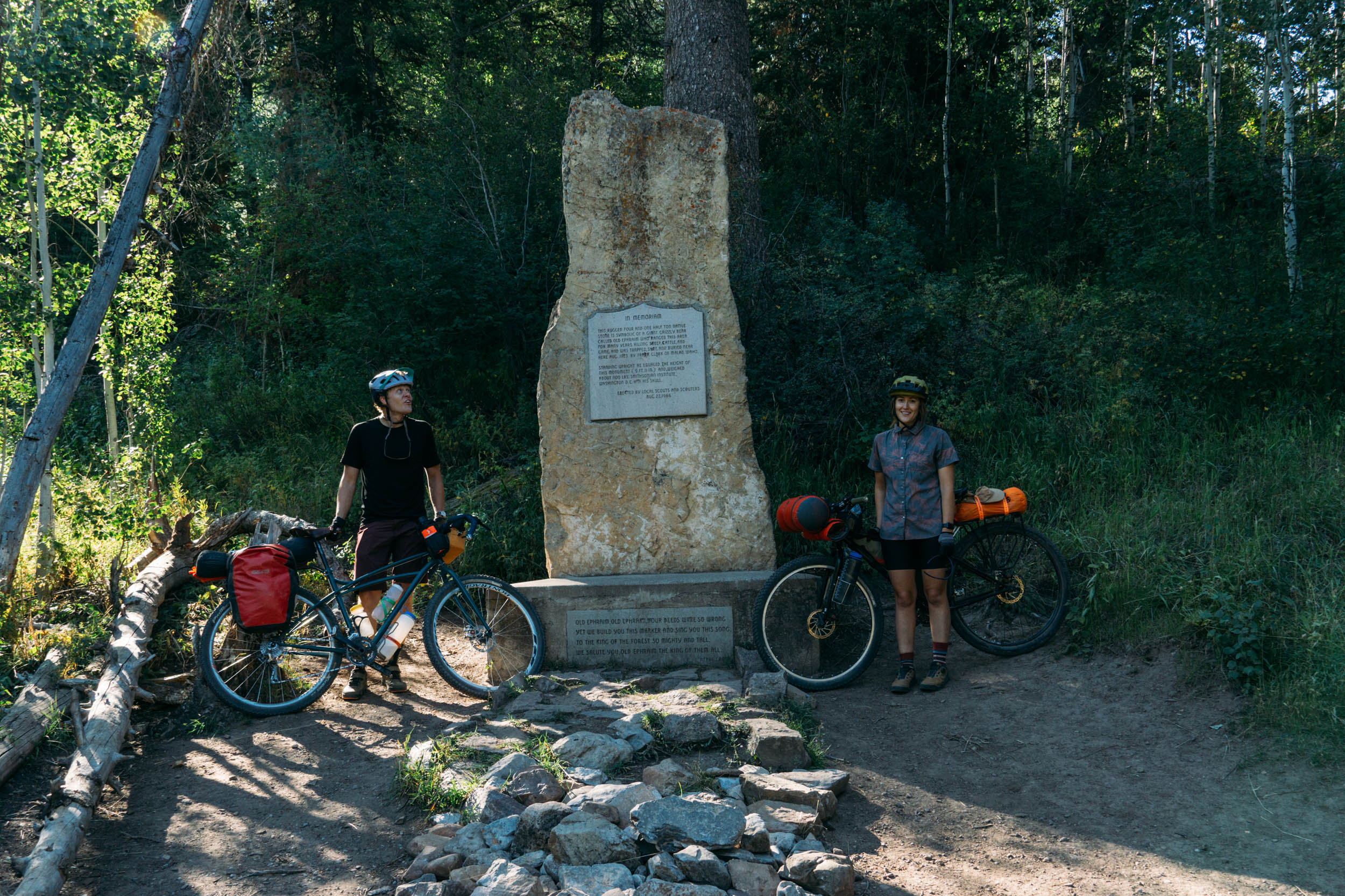
- Historic trails: Sections of the Mormon Trail and other pioneer-era routes.
Route Direction
- This route is intended and highly recommended to be ridden from Farmington to American Fork. Armstrong trail is a climb only trail and cannot be ridden backwards. All other trails, in theory, could be ridden backwards, but is not recommended.
When to go
- Late spring through early fall (June–October) is ideal. Snow can linger at higher elevations into June, and autumn offers golden aspens but an occasional snow storm which usually melts fairly quickly. The best time would be late June/early July. Certain dirt roads, such as the Skyline section of the Great Western Trail, remain gated to motorized vehicles until July 1st regardless of snow conditions. If you’re able to ride the route before then, thanks to a low or average snowfall year, you’ll enjoy much of it free from motorized traffic, which is a rare treat.
- Weather: High-altitude weather can change rapidly; be prepared for sun, wind, and sudden storms. Temperatures vary widely between valley floors and alpine ridges.
- This route does not cross any high mountain passes, so waiting for snowmelt is not a concern.
Logistics
- Travel Basics: Fly into Salt Lake City International Airport for the easiest access. Public transit makes a car-free start and finish possible. Uber XLs are available in most towns on the route.
- Access & Parking: The route is accessible via the UTA Frontrunner commuter rail from Salt Lake City to Farmington (start) and from American Fork (finish). Overnight parking can be tough, however, there is a ton of neighborhood street parking in Salt Lake City where a car can be parked on the street for several days/nights (near Sugarhouse and Liberty Park neighborhoods). Farmington has overnight restrictions but local hotels may offer extended parking if you call.
- Resupply: Towns along the route—Park City, Midway, American Fork—offer food, water, lodging and bike shops. Carry extra water and food for longer stretches like Farmington → Park City and the Ridge Trail section. Silver Fork Lodge, Solitude Mountain Resort and the Brighton Store are great “in-between” town resupplies.
- Dangers & Cautions: Technical descents such as Grove Creek Trail and Wasatch Crest require skill; some sections may need hike-a-bike. Loose rock, steep exposure, and occasional narrow paths demand caution. There is also overgrown vegetation on the Great Western Trail around mile 24 through roughly mile 28 if you’re going north to south.
- Trail intel: Pinecone trail is bi-directional and has some fast sections for downhill riders, make yourself known if you hear bikes approaching. Mill D trail is an awesome downhill, however, it is also a very popular hiking trail. Avoid late morning/mid-day descents on the weekends if you’re trying to ride it fast! The Ridge Trail can be slow moving and loose, these are some of the slowest miles on the route so fuel up heavy on supplies in Midway.
- Wildlife: Moose, mule deer, and the rare black bear sighting. Keep a safe distance and store food responsibly.
What Bike and Gear
- Plan for varied terrain: long climbs, technical singletrack, and high ridgelines. Early starts help avoid afternoon thunderstorms, and flexible timing allows for enjoying vistas, wildlife, and backcountry campsites.
- Hardtail or full suspension ideal, with 2.3”+ tires recommended. Lower gearing is helpful for sustained climbs; reliable brakes are essential for descents.
- Packing & Gear: Water-carrying capacity and filter is important for longer stretches without resupply. A camp stove is not needed if you are trying to save weight/room in packs.
Free camping is available on many sections of the route, and these spots are marked on the map. Three areas stand out for their scenery:
- Skyline dirt road: Campsites overlooking the Great Salt Lake, just after descending from Bountiful Peak.
- Desolation Lake: Serene alpine camping with a lake view.
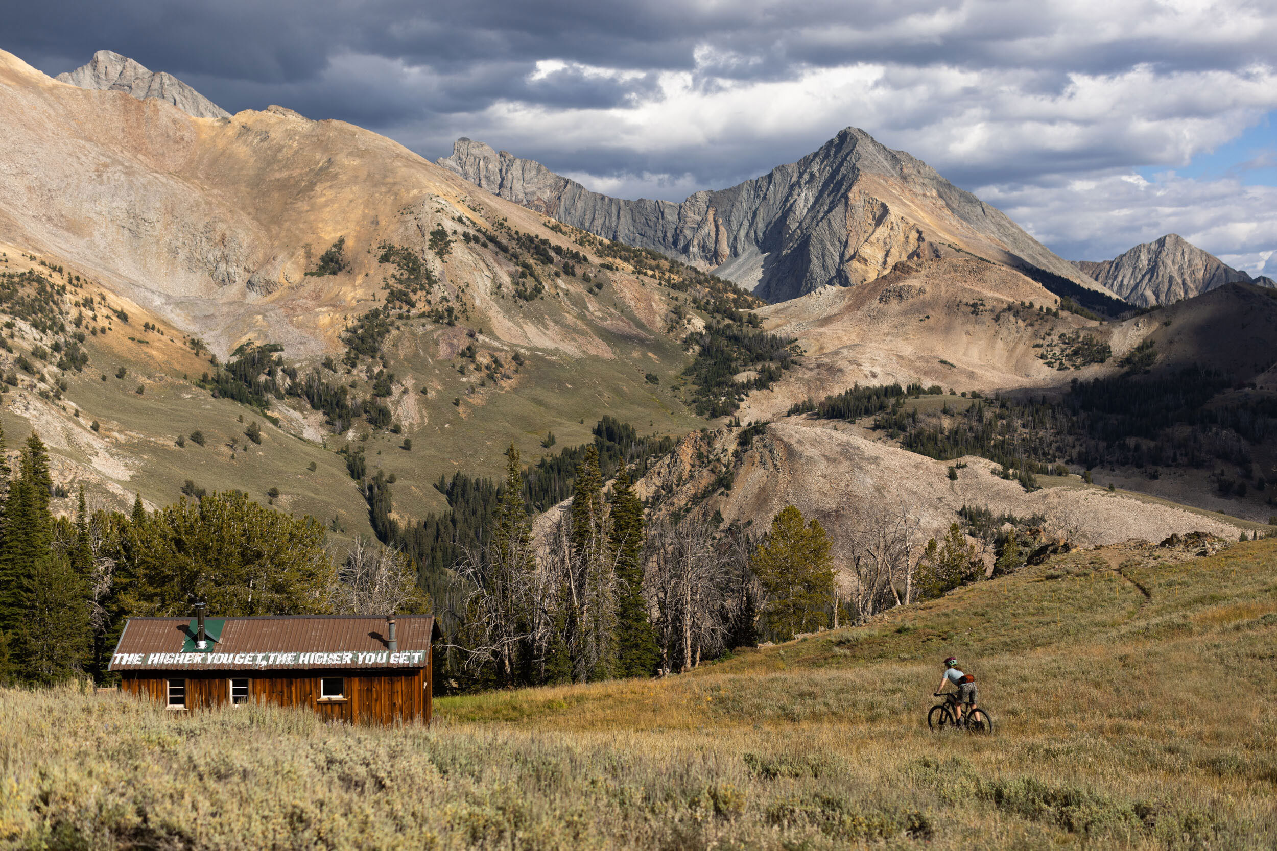
- Ridge Trail: Campsites with views of Mount Timpanogos.
Hotel rooms are convenient near Park City and Midway/Heber, where camping options are limited. Park City can be expensive, but budget-friendly options include Park City Hostel or hotels on the northeast side of town. Kimball Junction also offers cheaper accommodations, though you’ll need transportation to reach Downtown Park City.
Stealth camping is possible along much of the route, but be respectful of private property and natural areas. If you choose to stealth camp, pack up early to minimize impact and leave no trace.
Resupply & Water: Most days have at least one resupply. The longest stretch without food is Farmington → Park City (~47 miles, 8,000’ climbing). Midway → Ridge Trail midpoint (~5,000’ climbing) lacks water directly on route, however, you can drop 300-400 feet to Little Deer Creek Campground which usually has a creek to filter water. You will likely be able to see if the pond/creek has water while biking the dirt road above the campground directly on the route.
Remote but Accessible: Though parts feel wild, any ridge or climb can lead to a town. Wasatch development and friendly hikers make unexpected resupply possible. It’s common to have a jeep or side-by-side stop and offer beer or water near Bountiful Peak and climbing up to the Ridge Trail. Don’t bank on it though!
Natural Springs: There are three notable natural springs along the route:
- Halfway down the Mormon Trail (Mile 35): Beautiful spot, though it’s often better to use the stream at the bottom for a quick dip and water filtering.
- Ridge Trail (Mile 115): A convenient spring for water resupply. On a hot scouting ride, this was a crucial refill. While the water appeared very clean and likely safe to drink directly from the pipe, filtering is recommended.
- Near the top of Grove Creek (Mile 130): A refreshing spot to dip your legs and filter water if needed.
List of every possible resupply: Most water resupplies should be available from May – October.
- Mile 0: Harmons Grocery Store
- Mile 6: Spring/creek fo filter on the left side of the road
- Mile 11: Lake to filter water
- Mile 17: Small spring on the right side of road (Unreliable on flow) depending on time of year.
- Mile 35: Natural spring to filter water
- Mile 36: Stream/river to filter water and possible dip in.
- Mile 47: Kimball Junction with several resupply options include Whole Foods, Smiths, etc.
- Mile 50: Gas stations
- Mile 54: Downtown Park City with several resupply options
- Mile 69: Lake to filter water
- Mile 74: Spruces Campground – Spigot with clean drinking water near toilets
- Mile 76: Slightly off the main route is Silver Fork Lodge – Stay on Big Cottonwood Canyon if you would like to stop here. There is no store, just a restaurant and small bar.
- Mile 77: Solitude Mountain Resort. Entry 1 – Water and food when the bike park is open. Entry 2 – The village which has more options during regular business hours.
- Mile 78: The Brighton Store – Slightly off route, continue biking up Big Cottonwood Canyon rather than turning left on Guardsman Pass Road. Great store that caters to bikers’ needs.
- Mile 98: Downtown Midway with several resupply options include sit down restaurants and quick gas station stops. You can continue off route to Heber City for even more options – Especially for lodging.
- Mile 106: There’s a jeep road that descends a steep hill to Little Deer Creek Campground which may have a creek to filter water depending on time of year. If you look down the canyon, you may be able to see the water/pond and if it has water.
- Mile 112: There is a lake to the north of the Ridge Trail that may have water to filter. This usually dries up in late July/early August depending on the snow year.
- Mile 115: Natural spring for water refill.
- Mile 123: Water spigot (clean drinking water) at Timpooneke Trailhead
- Mile 130: Natural spring, water filter recommended to be safe.
- Mile 136: American Fork with several resupply options
Here’s a sample itinerary based on roughly 5,500 feet of climbing per day. Some riders may prefer shorter days, while others may push farther, but this provides a solid baseline for a thru-rider carrying a medium-light load. Mileage ranges are included to give a sense of distance, though elevation gain is the primary factor shaping each day’s effort.
location Farmington to Great Western Trail
Day 1 (21 mi +5,200′)
Take the Frontrunner to Farmington and resupply at Harmons and REI near the station. Climb quickly into the foothills on Farmington Canyon, a steady dirt road ascent with reliable water access. After roughly 3,700’ of climbing, a small lake offers backup water late in the season. Crest Bountiful Peak for sweeping views of the Great Salt Lake, then descend along dirt roads toward dispersed camping. Some of the best spots are near mile 21, just before singletrack begins on the Great Western Trail.
location Great Western Trail to Park City
Day 2 (36 mi +4,500′)
Begin with a rugged hike-a-bike and slow singletrack through one of the route’s most remote sections. Water is scarce until the Mormon Trail, roughly 2,500’ into the climb. Take in expansive views south toward Millcreek and the Cottonwood Canyons before rolling onto easier dirt road miles on Jeremy Ranch Road. A flowy singletrack leads into Kimball Junction, then a bike path carries you into downtown Park City for food and lodging.
location Park City to Midway
Day 3 (41 mi +6,000′)
Climb from Park City through alpine ridgelines and meadows to the Wasatch Crest, where world-class singletrack and sweeping views dominate the day. The Spine is a short rocky section that can be walked or ridden with skill. Descend Mill D past Desolation Lake, then climb Big Cottonwood Canyon using a mix of road, neighborhoods, and singletrack – Don’t miss Silver Fork Lodge and the Brighton Store which are both slightly off route. Crest Guardsman Pass for a first view of Heber Valley, then descend roughly 4,000’ on some pavement and then the W.O.W. Trail. Camp at Desolation Lake for a short day, steal camp near the W.O.W. for a medium day, or lodge in Midway or Heber City, depending on daily preference. You can also snag a room at Solitude Mountain depending on price and time of year.
Note: The Old Stage Road to Scotty’s Bypass avoids much of the busy Big Cottonwood Canyon Road, though it passes through private property. Several mountain bikers a day still prefer this route over the paved road.
location Midway to Ridge Trail / Mount Timpanogos
Day 4 (22 mi +4,700′)
Climb from Midway toward Mount Timpanogos on pavement and dirt two-track roads, then onto gravel and high-alpine singletrack. Water is scarce, with possible detours to Little Deer Creek Campground or Forest Lake for refill. The Ridge Trail is loose, rocky, and technical, with some hike-a-bike sections, but overlooks provide spectacular camping. Camp at or before Salamander Flats for the best high-alpine campsites.
location Ridge Trail to American Fork
Day 5 (20 mi +2,000′)
Descend to the Timpooneke trailhead which has clean drinking water, then ride dirt roads around the north side of Mount Timpanogos. Crest to see Utah Lake, then drop into Grove Creek Trail – a dramatic canyon framed by cliffs, waterfalls, and a natural spring. Short hike-a-bike sections may be needed. The route ends in American Fork, with lodging and resupply available. Car-free return to Salt Lake City is possible via UTA Frontrunner.
Additional Resources
Winter snowfall has a major impact on when this route becomes rideable, and conditions vary widely from year to year. A useful gauge is Alta Ski Area’s snowfall graphs. If Alta receives less than 500 inches in a season, the route is often clear by late May. With 500–600 inches (the average), expect early June. Above 600 inches, mid-June is more realistic. For example, in the record 2022–2023 season, Alta received 900 inches, and the route wasn’t fully rideable until July. Another good indicator is checking Trailforks or Strava reports for the Wasatch Crest—if riders are making it across with little hike-a-bike, most of the route should be good to go.
Certain dirt roads, such as the Skyline section of the Great Western Trail, remain gated to motorized vehicles until July 1st regardless of snow conditions. If you’re able to ride the route before then, thanks to a low or average snowfall year, you’ll enjoy much of it free from motorized traffic, which is a rare treat.
Visit this website for Frontrunner information. You can buy tickets in-person at the kiosk. The best place to load your bike is usually at the end of the train. There are bike symbols. The train usually stops for 1-2 minutes so be quick!


Terms of Use: As with each bikepacking route guide published on BIKEPACKING.com, should you choose to cycle this route, do so at your own risk. Prior to setting out check current local weather, conditions, and land/road closures. While riding, obey all public and private land use restrictions and rules, carry proper safety and navigational equipment, and of course, follow the #leavenotrace guidelines. The information found herein is simply a planning resource to be used as a point of inspiration in conjunction with your own due-diligence. In spite of the fact that this route, associated GPS track (GPX and maps), and all route guidelines were prepared under diligent research by the specified contributor and/or contributors, the accuracy of such and judgement of the author is not guaranteed. BIKEPACKING.com LLC, its partners, associates, and contributors are in no way liable for personal injury, damage to personal property, or any other such situation that might happen to individual riders cycling or following this route.
Further Riding and Reading
Here are some connected/nearby routes and related reports...

Please keep the conversation civil, constructive, and inclusive, or your comment will be removed.