


Redwood Backcountry Rambler
Distance
23 Mi.
(37 KM)Days
2
% Unpaved
60%
% Singletrack
44%
% Rideable (time)
98%
Total Ascent
2,564'
(782 M)High Point
1,952'
(595 M)Difficulty (1-10)
6?
- 7Climbing Scale Strenuous111 FT/MI (21 M/KM)
- 6Technical Difficulty Moderate
- 6Physical Demand Moderate
- 4Resupply & Logistics Fair
Contributed By

Dallas Mignano
Guest Contributor
Dallas grew up in Redding, California, central to the Shasta Cascade region. Since then, he has lived in various places across Northern California and Oregon. Not only does he love exploring the PNW and surrounding areas, but also sharing his experiences and getting others out there as well. He currently works as a creative director in the solar industry. Follow @dallasrm on Instagram and subscribe to the @BikeCampChill channel on YouTube.
The Redwood Backcountry Rambler (RBR) may only be 22.5 miles long, but it packs an awe-inspiring punch: towering old-growth redwoods, crystal-clear swimming holes, and a vibrant display of wildflowers and native flora. This adventure is one to savor. Take your time, meander freely, and soak in the rustic beauty of it all along the way.
Note that there is an influx of substantial tourism in the summer months, but backcountry camping can provide an immediate escape from the crowds as you climb into Little Bald Hills. Expect a variety of terrain: paved backroads, riverside hiking trails (to access some spots), forested gravel roads, multi-use mountain trails, a creek crossing, and some hike-a-bike sections.
A free permit is required to stay the night at Little Bald Hills backcountry camp. Check out the links below for more info on reserving a campsite. Water at camp is seasonal and limited. We stayed in early June, when the creeks next to camp were bone dry and the water spigot wasn’t running. There was, however, a reserve of water in the horse trough that could be filtered in a pinch. We made sure to bring extra water as we passed rivers and creeks beforehand. There are also picnic tables, fire pits, and a pit toilet located at camp.
Depending on weather conditions, this route may be rideable most of the year and a lot less crowded in the off-season (non-summer months). The Rock Creek crossing may be hard to pass if the water is high due to rain or snowmelt. However, there is an alternative, Paradise Trail, to bypass that section.
Route Difficulty
As mentioned, the main logistical issue is that water availability is limited at camp. Water may be more available at certain times of the year, but there are rivers, creeks, and springs that flow year-round. Packing extra water to take to camp is strongly recommended.
Route Development: This route traverses roads and trails that are a part of the Redwood National and State Parks, Smith River National Recreation Area, and Six Rivers National Forest. I’m an experienced bikepacker and creator of the Pine Mountain Observatory route. I planned this starter route with beginners in mind. It’s not intended to be the easiest, but with its short distance and varying terrain, it will give newcomers a full-fledged bikepacking experience in a bite-sized package.


Submit Route Alert
As the leading creator and publisher of bikepacking routes, BIKEPACKING.com endeavors to maintain, improve, and advocate for our growing network of bikepacking routes all over the world. As such, our editorial team, route creators, and Route Stewards serve as mediators for route improvements and opportunities for connectivity, conservation, and community growth around these routes. To facilitate these efforts, we rely on our Bikepacking Collective and the greater bikepacking community to call attention to critical issues and opportunities that are discovered while riding these routes. If you have a vital issue or opportunity regarding this route that pertains to one of the subjects below, please let us know:
Highlights
Must Know
Camping
Food/H2O
Trail Notes
Resources
- Old-growth redwood forest.
- Crystal-clear swimming holes.
- A great mix of riding terrain.
- Stay at a tranquil backcountry campsite in Redwood National and State Park.
- Vibrant wildflowers and unique flora.
- This route should be mostly rideable from March-November. Winters can be cold and wet and might make trails and creek crossings difficult to traverse. The summers can bring more tourism and traffic to the area. The late spring and early fall should have fewer crowds and still offer great riding conditions.
- The National Forest Service allows cars to be parked overnight along South Fork Road. There are specifically river access parking lots, like Sand Camp, next to the South Fork of the Smith River. No camping is allowed, though. Vehicles only. Be sure not to leave anything valuable. We had no issues.
- Tire width recommended at 2.2” or above. Sections of this route can get pretty rugged and rooty, but experienced gravel cyclists might be able to manage on narrower tires.
- The main camping spot for this route is the Little Bald Hills backcountry camp. A free permit is required, but can be easily reserved online. Please follow local laws and regulations accordingly.
- Be aware and cautious of bears in this area. There are signs at camp to lock up food in the provided bear-proof storage lockers and not leave crumbs. There can be mosquitoes, ticks, and poison oak as well.
- The recommended campsite is Little Bald Hills Backcountry Camp in Redwood National and State Park.
- Be aware and cautious of bears in this area. There are signs at camp to lock up food in the provided bear-proof storage lockers and not leave crumbs. There can be mosquitoes, ticks, and poison oak as well.
- There are many supply options on your way in and out (whether coming from Oregon via Route 199 or the Coast via Route 101).
- There are no food or resupply options along the route, so pack accordingly.
- Water can be accessed and filtered from rivers and creeks along the route.
- If you’re interested in celebrating at the end of the trip, I highly recommend a visit to SeaQuake Brewing in Crescent City or The Haul in Grants Pass. There are many other restaurants and markets, but those are two of my favorites that I keep coming back to when I’m passing through.
Sample Two-Day Itinerary
Here’s a two-day itinerary that can be easily accomplished in under 24 hours. You can also watch a video I made from our ride below.
locationSand Camp to Little Bald Hills
Day 1 (14.4 mi +2,189′)
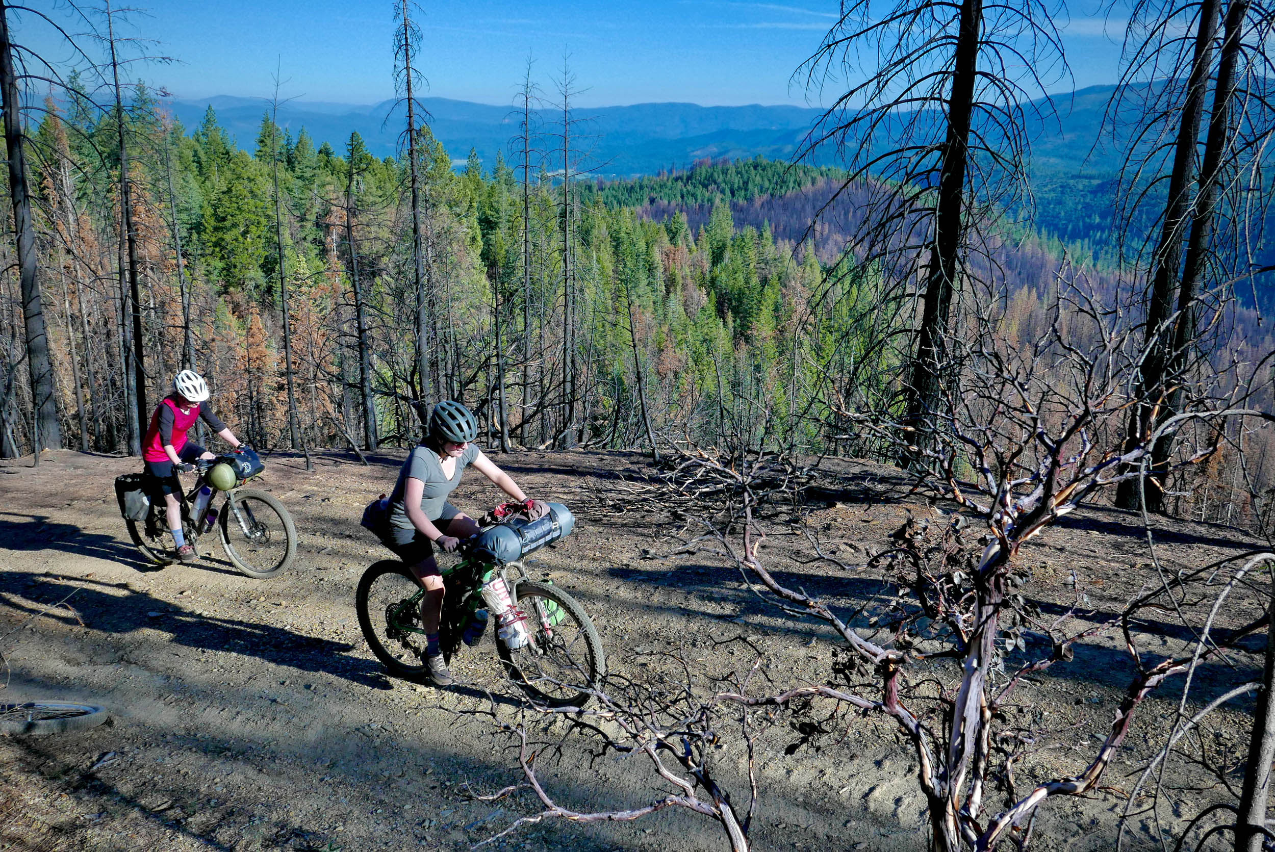
Leave the Sand Camp parking lot and follow South Fork Road along the south fork of the Smith River. There are many spots to stop along the way to hang out by the river. There are various riverside trails that can be explored and swimming holes to take a dip. Riders can then head towards Stout Grove to tour many giant redwoods in the area. After that, the route climbs up the Little Bald Hills Trail to the Backcountry Camp. You can expect a long, forested climb with technical sections along the way. Old-growth trees will continue to be seen throughout the day.
locationLittle Bald Hills to Sand Camp
Day 1 (8.1 mi, +375′)
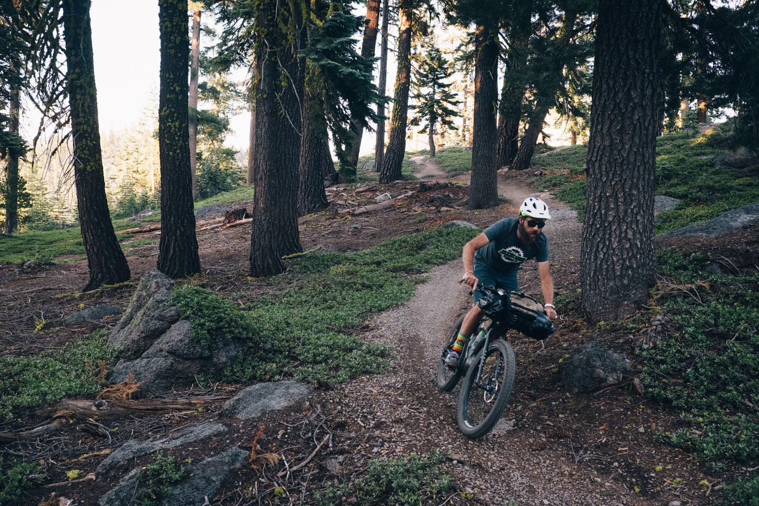
Start the ride from camp with a bit more climbing to the top of Little Bald Hill. There will be some meadows and open views of the surrounding mountains. The landscape and plants will start to change as you go. As the descent starts, you will begin to see many overlooking views into the gorge below. Keep an eye out for Darlingtonia and other unique flora along this section. There will be a fork where riders can take Paradise Trail (as a shortcut option) or Rock Creek Trail to get back to Sand Camp. The route takes Rock Creek Trail, where there will be a creek crossing towards the end (with tranquil swimming holes that are totally worth checking out). After crossing the creek, riders will climb up to a Jeep trail (Rattlesnake Ridge – Road FS-16N23) and follow it back to South Fork Road and Sand Camp.
Additional Resources


Terms of Use: As with each bikepacking route guide published on BIKEPACKING.com, should you choose to cycle this route, do so at your own risk. Prior to setting out check current local weather, conditions, and land/road closures. While riding, obey all public and private land use restrictions and rules, carry proper safety and navigational equipment, and of course, follow the #leavenotrace guidelines. The information found herein is simply a planning resource to be used as a point of inspiration in conjunction with your own due-diligence. In spite of the fact that this route, associated GPS track (GPX and maps), and all route guidelines were prepared under diligent research by the specified contributor and/or contributors, the accuracy of such and judgement of the author is not guaranteed. BIKEPACKING.com LLC, its partners, associates, and contributors are in no way liable for personal injury, damage to personal property, or any other such situation that might happen to individual riders cycling or following this route.
Further Riding and Reading
Here are some connected/nearby routes and related reports...

Please keep the conversation civil, constructive, and inclusive, or your comment will be removed.